
Last year my friend told me that she wanted to hike the entire John Muir Trail that summer. I told her that I would join her for the first part of her hike, especially if she started at Mt. Whitney since it's a hike I had on my bucket list. Due to injuries and the inability to acquire a permit, she wasn't able to do the hike. So she moved her plans to this summer. Once again I told her that I would hike Mt. Whitney with her if she was able to get a permit to start the JMT from the Whitney Portal. She was able to get a single permit for herself in May to start her hike on September 7, 2017. Since she was only able to get one, I thought I was off the hook....I mean out of luck. Fast forward to August 14th. She calls to tell me that she was able to get a permit for me if I still wanted to hike Mt. Whitney with her. I was very nervous but agreed. I was worried that three weeks was not enough time to get ready for a hike labeled as an "extreme" day hike.
I thought about backing out probably 100 times but in the end I decided to suck it up and at least attempt it. I knew I would kick myself if I didn't try. I did two training hikes, Griffith Peak and Fletcher Peak, both near Las Vegas and range between 11,060 and 10,255 feet.
About a week before we were scheduled to leave, two permits opened up allowing us to start on September 6th and stay overnight. I felt a lot better about this option because the idea of hiking over 22 miles in one day sounded miserable. We decided to leave on Wednesday morning, drive to the Eastern Sierra InterAgency Visitor Center to pick up our permits and bear canister, grab a quick lunch in Lone Pine and then head to the trailhead, Whitney Portal.
All went as planned. We arrived at the Whitney Portal, used the pit toilet, and weighed our packs. Hers weighed 40 pounds and mine weighed 43 pounds. I was carrying a few additional items for us to help lighten her load since she was packed for a 2-3 week hike. We started our journey at 1:30 PM.


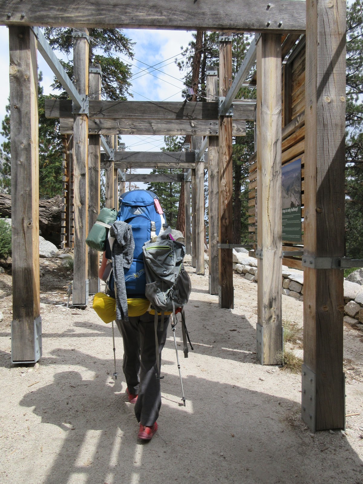
The Whitney Portal is an actually wooden structure that you walk through to start the hike.
The trail started to climb immediately. Our packs were heavy but our spirits were high. We chatted with each other and with other hikers we came across. We were excited to finally be starting something that we had talked about for over a year.
At about the 0.5 mile mark, we came to our first real water crossing, the North Fork of Lone Pine Creek. I knew that all the crossings would either have rocks or logs to help us across but I was still nervous about falling in. The weight of our packs affected our balance but we took it slow and made it across without issue.

Right after the creek crossing, we entered into John Muir Wilderness in the Inyo National Forest. We were surrounded by trees. It was beautiful.

Shortly after entering, we saw two bright flashes of lightning followed by almost immediate claps of thunder. That was a bad sign. I had packed rain gear but had hoped not to use it. After hearing more thunder, we decided it was time to get ready for rain. It started to rain right after I finished getting dressed and putting my pack cover on. It ranged between a light drizzle to a downpour. We just had to put our heads down and continue on. It rained off and on for the next several hours.

During one of the rain breaks, we were greeted with a beautiful rainbow as we looked into the valley.

At around the 2.25 mile mark, we came to my favorite water crossing. It was a long section of logs constructed as a walkway. The water running underneath sounded so peaceful. The logs were stable and wide enough to walk across without worry.

At the 2.5 mile mark, we passed Lone Pine Lake. It was a little off the trail so we decided not to go to it but to continue on our path. Shortly after that, we entered the Whitney Zone. All hikers beyond this point are required to have permits and a tag on their packs.

Near the 3.25 mile mark we entered into a beautiful meadow. This was the first time my imagination went wild and I imagined seeing a bear wandering through the foliage. Luckily, that was the closest I got to having a bear encounter. We walked along the edge of the meadow with several water crossings. At the end of the meadow, 3.5 mile mark, was Outpost Camp. This is the first of two official camps along the trail. It was a large flat area near a waterfall with lots of trees.

Our original plan had been to make it 6 miles on day one and camp at Trail Camp. We realized that was not going to happen because we were losing daylight. We decided to go on a little more and see if we could find a spot along the trail.
At the 4 mile mark was Mirror Lake. There was a sign that stated no camping allowed. You're not allowed to camp within a certain distance of water and there was not enough ground space to create that distance.

My friend had an app downloaded to her phone that showed where campsites were along the trail. It showed one 0.2 miles above Mirror Lake so we decided to check it out. It was a perfect spot!
We talked to the few hikers that passed our site on their way down the mountain. We set up camp, cooked dinner, forced ourselves to eat something and chatted until we decided to go to sleep. I saw a few ground mice but they stayed far enough away.
While we were getting ready for bed, I had the scariest moment of the trip happen. We heard a loud rumbling noise coming from the mountain above us. I looked out the tent but since it was dark I couldn't see anything. The sound lasted for about a minute. It was a rock slide. Somewhere above us, a huge section of scree let loose and started sliding down the cliff. All we could do was pray that it wasn't going to hit us.

As usual, I got very little to no sleep that night. I was tired but just couldn't go to sleep. My friend was able to sleep soundly so I was happy for that. I heard a group descending the mountain around 9:30 PM. I hope they stopped at Outpost Camp because it was going to be a very late night if they were heading for the portal. I heard the first hikers pass our tent at 2:30 AM on their way up the mountain. I heard another group go by at 3:30 AM.
I had set my alarm for 4:00 AM. It ended up not being necessary since I was already awake. We woke and started getting ready for the morning. I ate the other half of my dinner from the night before. I was much more hungry this time around. I repacked my backpack and helped break down our campsite. It was still dark but luckily there was a full moon and we had our headlamps on. We ended up starting our hike at 5:30 AM.
It was surprisingly peaceful to hike in the dark. It was calm and quiet. I had decided to hike the 1.8 miles to Trail Camp and drop off my large pack and switch to my daypack. I knew this would take some time so I did not stop to wait for my friend and went straight to the camp. At one point I realized that the moon was giving me a shadow. That was pretty cool. As I hiked, it was beautiful to see the sky go from pitch black to all the varying shades to daylight.

At the 5 mile mark, I passed Trailside Meadow. It was beautiful. It was the first snow I remember seeing. On the other side of the meadow was a large mountain side full of scree. I'm certain that was the area that had the rock slide the night before. I realized that there was no way it could have reached us so that made me feel better.

Around 6:30 AM, I saw my first rays of sunlight peak over the ridge. It was a beautiful experience. I was alone but felt so much peace.

I reached Trail Camp in just under two hours. Trail Camp is at the 6 mile mark on the trail. It is located at the base of the 99 switchbacks. Once there, I dropped my pack next to some rocks and grabbed my water purifier to refill my Camelback bladder. I was using my friends Sawyer Mini Water Filter. I quickly realized that I couldn't fill up the bladder in the standing pond water. I was barely able to get 8 ounces of water in it. The water was freezing and I had to submerge my hand to fill it. I couldn't handle it anymore so I figured that was enough water. I then had difficulty getting the filtered water out. I was frustrated. Just then I heard a guy ask if anyone wanted his extra water. I immediately ask for it. A few guys came over. One figured out how to get the little bit of water I had collected filtered and into the bladder. Then the other guy poured his water into the bladder until it was full. I was so grateful! I then went back to my gear and pulled my bear canister out. I lodged it next to a rock away from tents and near other bear canisters. Then I transferred want I wanted to take with me to the summit into my daypack. I also ate a bit of dried fruit while I waited for my friend.
She arrived a little over 30 minutes after me. She refilled her water and then came over to me. We talked for a few minutes and then finally decided that I should continue on without her if I wanted to summit and get back to the portal before it was too late. She was carrying the stove and we had planned on eating a hot lunch together so we had to prepare our lunch then. I would just carry it with me until I was hungry. We said our goodbyes even though I knew I would see her on the trail at least one more time while I was on my descent. After all was said and done, I had spent over 1 hour and 20 minutes at Trail Camp.

I left my friend and Trail Camp and started the neverending 99 switchbacks. I don't know if there really are 99 switchbacks but I can tell you that it was way too many. They climb 1600 feet in approximately 2.5 miles. There was running water around a quarter of the way up that I had to cross on several switchbacks. They were icy so I had to watch my step. About a third of the way up is a section of old cables. I'm not certain why they are there and what help they would really offer but it offered a cool photo so I took it. I've seen pictures of this section during the spring and it is covered in snow and ice so I'm sure the cables are there for that time of year. At this point I met a man named Joe. He was 58 and from California. We chatted for a few minutes and then we continued on our separate ways.
I found it interesting that there was a group of us that were hiking at about the same pace. We would continually leap frog one another whenever one of us would take a break. There was a group of three men (a dad with his two grown sons), two girls from Idaho, and Joe. We ended up talking off and on as we made our way up the switchbacks. It made for a nice distraction.

Finally, the neverending switchbacks ended as I made it to Trail Crest. It is at 13,600 feet and allows you to look down both the east and west sides of the mountain. It was breathtaking.

Just below Trail Crest is a sign stating that we are entering the Sequoia National Park. It's pretty cool to think about all the different areas I crossed through on the hike.

Being able to look west and see new scenery was a nice change as well. The remainder of the hike to the summit was along the western edge of the mountains.

After the sign, I began a 0.2 mile downhill section. I was happy to be going downhill but I also knew I would regret it on the return trip. At the bottom of the downhill section there was a split in the trail. To the left was the John Muir Trail and to the right was the final section of the Mt. Whitney Trail. This is where my friend planned on dropping her heavy backpack and continuing to the summit. There were several other packs along the rocks where other JMT hikers had done the same thing.

I had hoped to wait until the summit to eat lunch but at the pace I was going I knew it might be two hours away still and I was hungry. So I found a nice little seat that overlooked the Sequoia National Park and ate my lunch. It was no longer hot but it wasn't cold either. I sat in the sun, amazed by the beauty surrounding me. I was also able to chat to all the hikers going up and coming back down. It was a nice lunch break.
As I was finishing lunch, Joe met back up with me. He decided to sit down for a break as well. He told me that his hiking partner had to turn around on the switchbacks and decided to head back to the portal. He asked if I would be okay if we hiked the rest of the day together. Since I was going to be alone for the rest of the day too, it sounded like a great idea to me.
We set off again. There were a few sections that were difficult between there and the summit. There were a lot of small boulders that required a small amount of climbing over. There were also sections with sheer drop-offs and narrow trails. There were also areas of downhill that once again made me regret them because I knew we were going to have to climb back up them.

For most of the 1.9 miles after the JMT junction, the trail runs straight along the west edge of the mountains with only one switchback. Towards the top of the mountain we came across our only snow crossing. It was well worn so I didn't feel it necessary to put on my snow cleats. Descending hikers had passed us and told us that we were almost there and that once we crossed the snow we would turn right towards the peak.

They were right. We turned right and had a few more switchbacks as we climbed to the summit. It was such an awesome feeling to finally be able to see the Mt Whitney hut because that meant we were almost there.
At 1:30 PM on September 7, 2017, I reached the summit of Mt. Whitney, the tallest mountain in the contiguous United States. It was exhilarating!

I signed the registry at the hut with "For my boys. Do hard things. Never quit!" Then I grabbed a sign someone had made and had my picture taken with it. It said " Mount Whitney, 14,505 feet, September 7, 2017."

I had to take my customary picture at the Geological Survey plug. For some reason there were four plugs on different rocks on the summit. I just picked one to take a picture of.

Just before I started my descent, I stopped by the hut to check it out. It is a stark contrast to the barren rocks at the summit.

Inside the hut is a reminder that lightning is deadly and the hut should not be used as a shelter during a storm.

After spending about 30 minutes on the summit, Joe and I started our descent. About 30 minutes into our descent, we crossed paths with my friend as she was making her final push towards the summit. We stopped and talked for a few minutes. She was in high spirits and both excited and nervous about her journey. I gave her one final hug and a few words of wisdom and encouragement and we said goodbye again.
As I continued my way back towards the JMT junction, I stopped to take a picture looking through one of the windows to the east of the summit.

I also took a picture of Guitar Lake. It is to the west of the summit. That is where my friend hoped to camp for the night on the JMT.

That was the last picture I took. I knew that I was in store for a long, hard descent back to the Whitney Portal. I arrived back to Trail Camp at about 5:20 PM to repack my backpack and bear canister. People had commented on marmots and other small animals messing with packs left at Trail Camp but nothing had been disturbed. Joe and I refilled a bit of our water and each had a peanut butter and jelly sandwich. We left Trail Camp at about 6:00 PM.
We pressed hard to go as far as we could before sunset knowing we were going to be finishing in the dark. The first few miles went fairly quickly and before we knew it we were 4 miles out and at Mirror Lake. That's when we put our headlamps on and it was completely dark by 3.5 miles out. The final 2.5 miles seemed to last forever. We were both hurting. There was no more talking, only focusing on putting one foot in front of the other. The last thing we wanted was to get injured on the trail after dark miles from help. The final 1.5 miles were sheer torture. Everything hurt. We knew we were close but it was so dark we couldn't see how close so we just kept walking.
Finally, at 10:15 PM, we crossed through the Whitney Portal for a final time. I was so elated I almost cried. Joe said he did too. I was so happy to be done and so happy I had decided to reserve a hotel for the night 30 minutes away in Lone Pine, CA. Once we were at our cars, Joe and I hugged and said our goodbyes. He thanked me for sticking with him and I did the same. We both agreed that God knew what he was doing when our paths crossed. I will never see him again and I don't even know his last name but I am so glad I had him with me for the day.
Hiking Mt. Whitney has been something I have wanted to do for a few years but it was something that I never thought possible. I am amazed at what my body is capable of doing. It is strong and my mind holds a "never quit" attitude. I may not be the size or weight I want but I am fearfully and wonderfully made. I am able to do hard things.
This comment has been removed by a blog administrator.
ReplyDelete