
On 12-22-15, I decided to go hiking. I wanted to get one more good, long hike in before I have my knee surgery. So I loaded my dog and me up with my friend and her dogs and we went to Valley of Fire. It is a state park about an hour NE from Las Vegas. It is Nevada's oldest and largest state park.

We picked Charlie's Spring Loop as our hike for the day. It is a 6.7 mile, moderate loop in the backcountry of the park. The trial is unmarked and not maintained. We printed out the below map to help us find our way.

We left Las Vegas as 7:00 AM and arrived at the park just after 8:00 AM. The west entrance booth was closed so we paid our entrance fee in the drop box. It is $10 per vehicle and $8 for Nevada residences. As we were entering the park, we saw a small herd of desert big horn sheep. It was really cool to see them next to the road.

We stopped at the Visitor Center to use the restroom and pick up a park map. The trailhead is a few miles east of there so we loaded back up into the car and made our way there. There is roadside parking on both sides of the road near the John Clark Memorial. The trail begins there. We parked on the south side of the road and gathered our gear.

I decided to bring my daypack instead of just my hydration pack. I had dressed in layers and wanted the extra storage for when I needed to shed clothing. I was carrying 3 liters of water, my lunch, 3 bones for Black Jack, my first aid kit and my emergency kit (a gallon size Ziploc full of all things needed in emergencies). I also had my walking poles since my knee still lacks stability.

We walked to the memorial and then began our hike. It stays in a wash for the majority of the hike. The footing alternated between loose sand, dried earth, gravel, and small rocks. The hiking poles were not necessary for a healthy hiker but I'm glad I had mine.

Since this trail is a remote hike, we knew that we would probably not see any other hikers on the trail and we were right. After a few minutes of hiking, we decided to let the dogs off their leashes and let them explore. They had a blast! It was a great place to let them roam since we were trapped in the wash so their routes were limited. It made my heart happy to see Black Jack enjoying his freedom.

After a few miles of hiking, we approached a small section of narrows. It was dry but would have made a beautiful waterfall section if water was flowing.

We started into the narrows and were able to navigate our way with ease. I was a bit nervous since I didn't know what to expect but I was able to do all the scrambling even with my injured knee.

The most strenuous section was about a 20 foot drop that was a little steep. My friend and her dogs went first and had no problems. We threw our poles to the bottom to free up our hands. I went next and stopped about halfway down to help Black Jack. He was very nervous at this section. Whenever he would try to go down, his paws would slip and he would back up. He weighs over 80 pounds so I wasn't sure how we were going to get him down if he couldn't do it. My friend came back up to me and with her help, we were able to coax and cheer him down small sections at a time until he was finally at the bottom.

We finished the narrows section and continued to walk along the wash. It was a very interesting area. The rocks varied in appearance, some even resembled concrete. It was neat to see what the power of water can create.

We finally began to see water. Charlie's Spring has water year round. We didn't see where it started but walked along it for probably a mile or so. The dogs loved it and enjoyed drinking and playing in it.

The map noted that we would see a power line road entering from the right and exiting from the left and that we were to take it to the left. We saw some power lines high overhead but never saw a road. We continued walking along the wash. Eventually, we walked under an overpass. We looked at the map and didn't see that road. I began to think that something was wrong. As the miles began to add up, we realized that we somehow missed the turn. We decided to stop and eat lunch. I gave Black Jack his 3 bones. We were able to get phone service so we looked at our location on a map. We saw that the road we had recently walked under was North Shore Road, which is in Lake Mead Recreational Area. I knew where we were and knew that we were no longer near where we wanted to be. We decided to turn around and head back to North Shore Road. We had two options at this point, we could walk along the road or retrace our steps. We were at about the 6 mile mark at this point. We weren't sure about the distance it would be on the road but I was worried about getting Black Jack back up the narrows section. We decided to walk along the road back to our car. I figured it was about 5 miles. We put our dogs back on their leashes and made our way to the road. Once we were back on the road, we were able to use our phone to see the distance and it was about 7 miles. The walk was longer and at an incline but it was not hard since we had stable footing. The occasional car passed us as we walked. I could feel a few hot spots forming on my feet but decided to keep walking until I reached the Lake Mead north entrance booth. Once I got there, I was a few minutes ahead of my friend so I stopped and doctored my feet. I dumped out sand and small rocks and added a band-aid. Once my friend joined me, we continued our trek. We were getting closer. Immediately after the fee booth, there was the Valley of Fire Hwy. We turned onto it to make the final few miles push back to our car. It was a steady incline into the sun. The road offered a nice sandy shoulder area so I was able to walk on it with my dog to help save his pads. We finally reached the park entrance and stopped to get a picture by the sign.

Both mine and my friend's feet were really hurting. I knew that we only had about a mile left so we continued on. We passed the west entrance pay area. I stopped to use the bathroom and wait for my friend. She opted to not stop because she was afraid she wouldn't be able to start again.
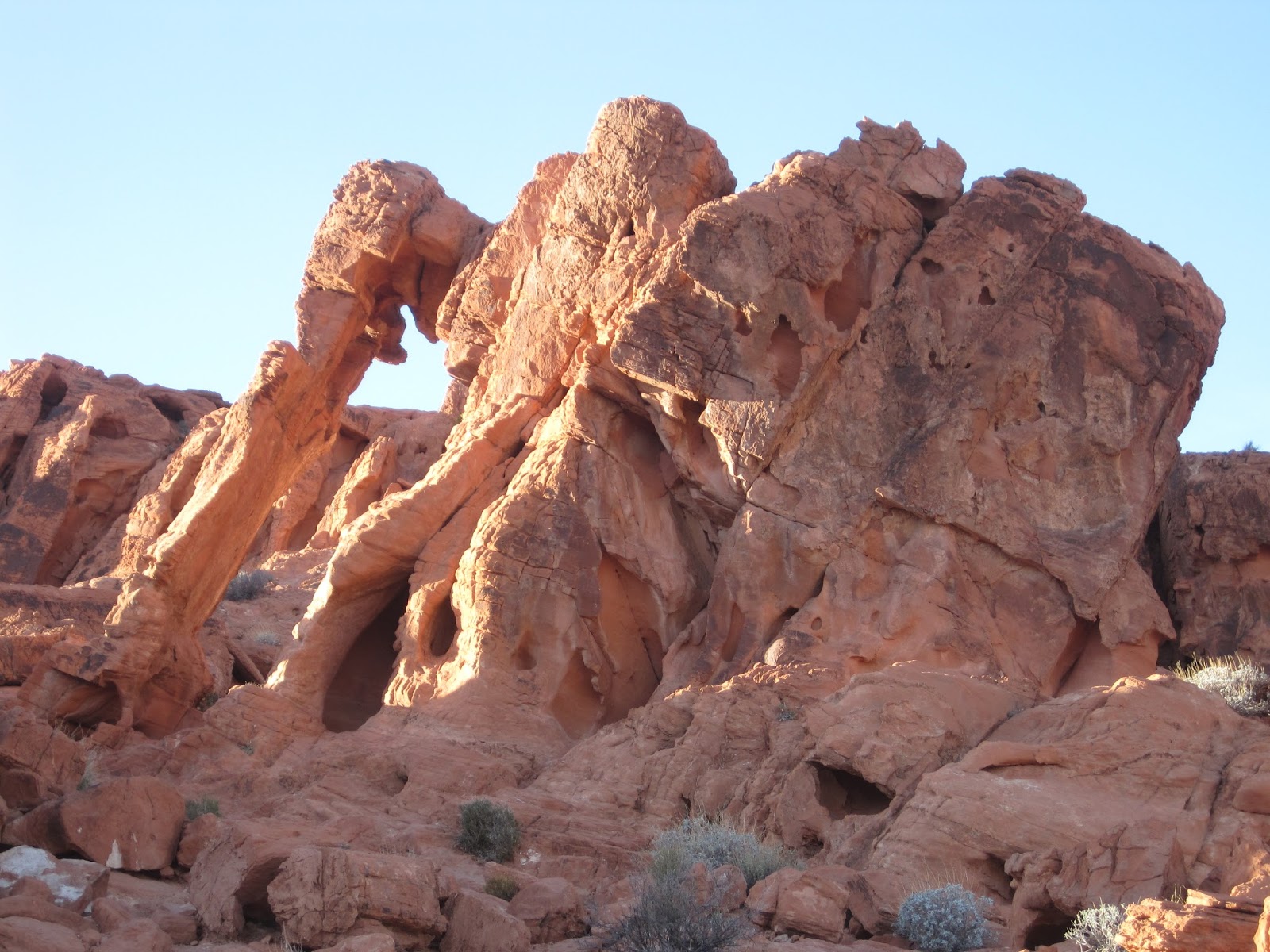
We passed the famous Elephant Rock and then continued along a trail over the crest of the ridge. Once I was on the other side, I was greeted with this beautiful sight. I knew that we were almost to our car so I reveled in the sight.

When I was finally able to see the car I yelled back to my friend. Black Jack and I reached the car first and we were so happy. I was really looking forward to sitting down and taking off my shoes. When my friend reached the car, she told me our total mileage was 13.2 miles in a total time of 6 hours (moving time of 5:15).

On the ride home we talked about it and think we figured out how we missed the turn. The hike is in a wash and is not maintained. We have several times a year where there are flood-like conditions. There must have been enough flooding through the wash since the map was made that the road entrance and exit have been washed away. The landscape must have changed enough that we were not able to see the landmarks that we needed.

I had said that I wanted a nice, long hike before my surgery and I got what I asked for. It wasn't a super difficult hike, it was just long. I am very glad that we did this hike in the winter because there was no shade or protection so this hike could have been detrimental if it had been during the summer. My words of advice for future hikers of this trail is that if you reach the power lines, you missed the road. You should either turn around there and retrace your steps back to the trailhead or do some extensive exploration around there to try and find the road to continue the loop. Happy hiking!
No comments:
Post a Comment